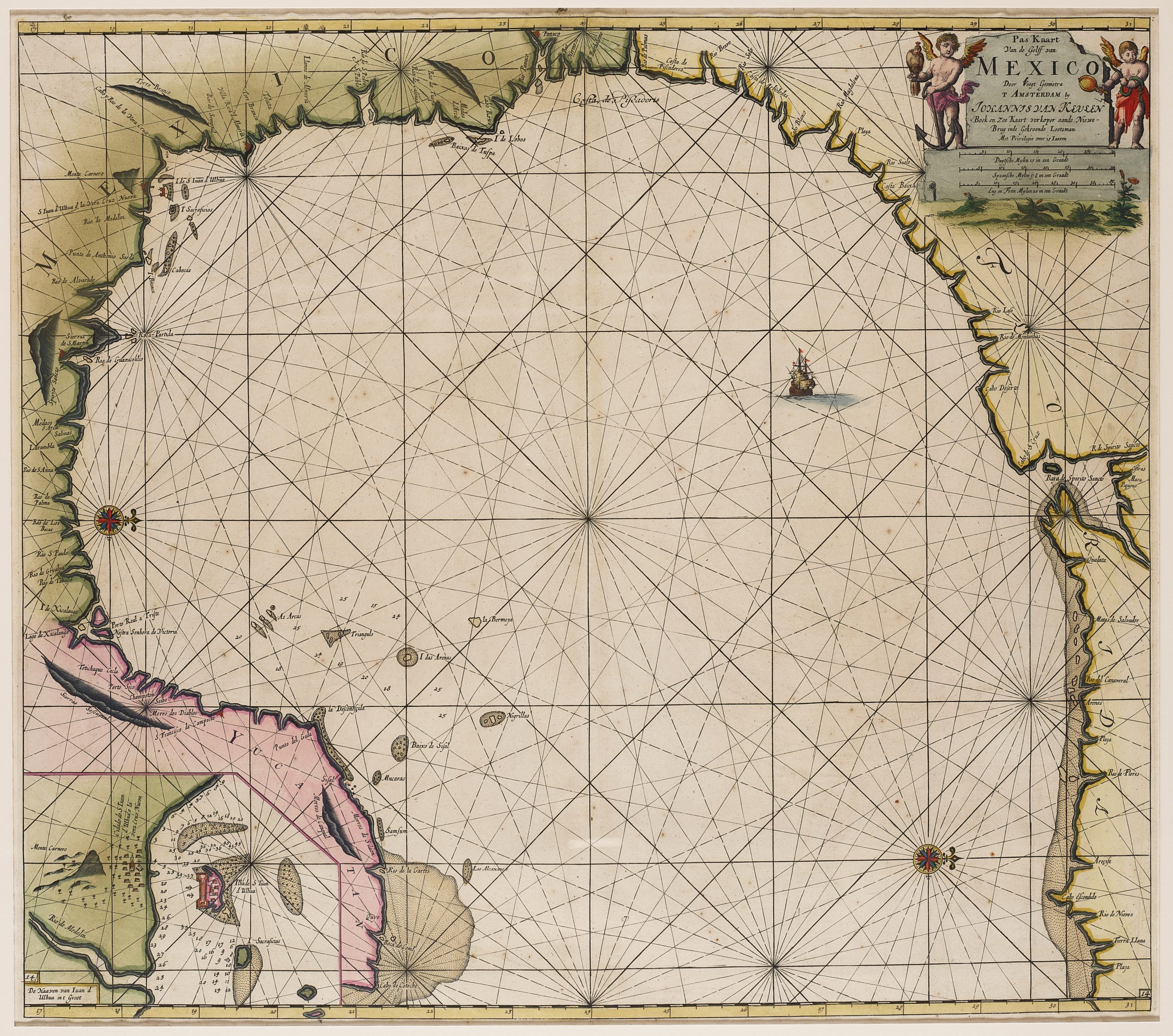
Chart of Gulf of Mexico
by
Johannes van Keulen
Oriented with West toward the top of the page
Detail
Date of first edition: 1684
Date of this edition: 1697-1709
Dimensions (not including margins): 50,6 x 57,5 cm
Dimensions (including margins): 53,3 x 61 cm
Condition: Very good. Nice outline colouring. Some minor spotting. Note: the brown color at the top margin is no age-toning or browning: it is the result of spotlight when the picture was taken.
Condition rating: A
Verso: blank
Map reference: Koeman, Keu (129); Burden 592
From: De nieuwe Groote Lichtende Zee-Fakker, Amsterdam
Price (without VAT, possibly to be added): €2 800,00 (FYI +/- $3 108,00 / £2 492,00)
Unless otherwise specifically stated on this map page, we charge the following expedition costs in euro (unfortunatelly, gone up with Covid, but still too low in reality!):
– Benelux: 40 euro
– Rest of Europe: 60 euro
– Rest of the World: 100 euro
In stock
T

Van Keulen shows the Gulf of Mexico
In none of his four voyages to the West in search for spices would Columbus enter the Gulf of Mexico. On his first, second and fourth voyages, he made landfall on Cuba, the closest he would get to the Asian spices… The first European exploration of the Gulf of Mexico was by Amerigo Vespucci in 1497. In 1517, Francisco Hernández de Córdoba explored the Yucatán Peninsula; this was the first European encounter with an advanced civilization in the Americas. Many expeditions would follow. More than 100 years after Columbus, the nature of the mid-American missions had, of course, completely altered: the Spanish aimed at territorial gains and economic exploitation.
This spectacular (and somewhat funny) chart of the Gulf of Mexico (oriented with West toward the top of the page) shows the coastlines of Florida, Alabama, Mississippi, Louisiana, Texas and Mexico to Yucatan. Its geography is largely derived from a rare chart by Hessel Gerritsz from ca. 1631, who had made a trip to the Caribbean in 1628. Johannes van Keulen would publish his version of the Gulf of Mexico in De Nieuwe Groote Lichtende Zee-Fakkel, in 1697.
The entire region had not developed cartographically in a while and most of the toponyms are old Spanish ones. According to Burden the Cabo Escondido is the current Cape San Blas, at Apalachicola, Florida (just outside Tallahassee, Florida). More visible is the huge Baja de Spirito Sancto, the mouth of the Mississippi River. The Mississippi River was actually explored during a land expedition: on May 8, 1541, Hernando de Soto became the first recorded European to reach the Mississippi River, which he called Río del Espíritu Santo (“River of the Holy Spirit”). To the West lies the estuary of the Rio Grande (Rio Bravo). Further in Mexico are the still so-called Panuco and the Rio Panuco.
In the top left inset van Keulen pictures Vera Cruz and the islet of San Juan d’Ulhua. When Hernán Cortés set foot on Good Friday in 1519, he founded a city which he called La Villa Rica de la Vera Cruz (rich town of the true cross); it became the first European settlement on the Mexican mainland. In 1523, Charles V granted the city a coat of arms, an absolute primus for any settlement in the New World. Vera Cruz would be the most important Spanish trading settlement in Mexico, especially export of gold and silver. Opposite the city, on the island, a powerful fortress was built in 1556, which also served as a prison and transshipment place for precious metals (see picture).
By the way, Vera Cruz was during a long time a key transit port for Filipino goods to Spain! First the Portuguese, then the Dutch had blocked he route via the Cape of Good Hope. The goods were first shipped to Acapulco on the Mexican west coast, and then transported over land to this Atlantic port. Richard Haykluyt reported that Hawkins and Drake narrowly escaped Spanish anger near Vera Cruz in 1568 when they are (so they say) on a “peaceful trade mission”’. However, they had just captured a few Spanish vessels.