Central and Southern Spain – Partie Meridionale Des Etats de Castille
by
Gilles Robert de Vaugondy
Detail
Date of first edition: 1751
Date of this edition: 1757
Dimensions (not including margins): 47,5 x 55,5 cm
Condition: excellent. Sharp copper engraving printed on hard paper. Superb original outline colouring.
Condition rating: A+
Verso: blank
From: Atlas universel
Price (without VAT, possibly to be added): €300,00 (FYI +/- $333,00 / £267,00)
Unless otherwise specifically stated on this map page, we charge the following expedition costs in euro (unfortunatelly, gone up with Covid, but still too low in reality!):
– Benelux: 40 euro
– Rest of Europe: 60 euro
– Rest of the World: 100 euro
In stock
Related items
-

Strait of Gibraltar – Carte nouvelle de l’Isle de Cadix…
by Homann HeirsPrice (without VAT, possibly to be added): €400,00 / $444,00 / £356,00 -

Cordoba – Corduba
by Georg Braun and Frans HogenbergPrice (without VAT, possibly to be added): €1 200,00 / $1 332,00 / £1 068,00Idyllic view full of history
-

Toledo (Castile) – Toletum
by Georg Braun and Frans HogenbergPrice (without VAT, possibly to be added): €1 500,00 / $1 665,00 / £1 335,00 -

Peniscola (Valencia)
by Richard WahlPrice (without VAT, possibly to be added): €450,00 / $499,50 / £400,50Sublime document of history


de Vaugondy
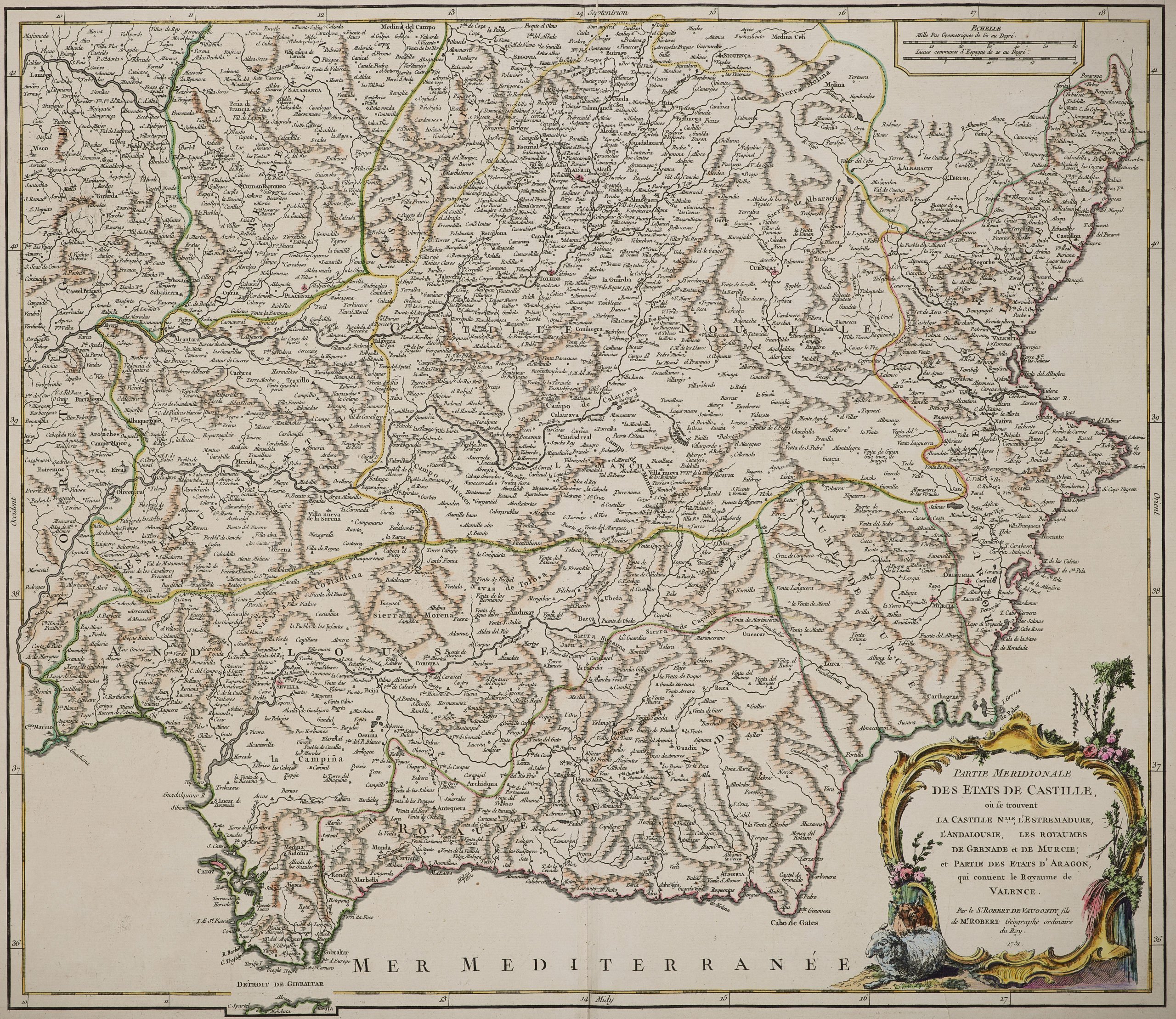
This handsome map was compiled by Gilles Robert de Vaugondy (1688-1766), also known as Le Sieur or Monsieur Robert, and his son, Didier Robert de Vaugondy (c.1723-1786), leading mapmakers in France during the 18th century. It was published in their Atlas Universel, Paris, 1757, one of the first atlases based on scientific surveys, in the tradition of Jean Baptiste Bourguignon d’Anville and Guillaume de l’Isle. The ´Atlas Universal´ was one of the first atlases based upon actual surveys. Therefore, this map is highly accurate (for the period) and has most contemporary town names correct.
This large and detailed map shows the central and southern part of Spain, including areas such as Madrid, Toledo, Sevilla, Cadiz, Granada, Malaga, Alicante and Valencia. Its full title is “Partie Meridionale des Etats de Castille, ou se trouvent la Castille Nlle., l’Estremadure, l’Andalousie, les Royaumes de Grenade et de Murcie; et partie des Etats d’Aagon, qui contient le Royaume de Valence”. The map renders the entire region in extraordinary detail offering both topographical and political information with forest and mountains beautifully rendered in profile. A beautifully engraved title cartouche in included in the bottom right quadrant.