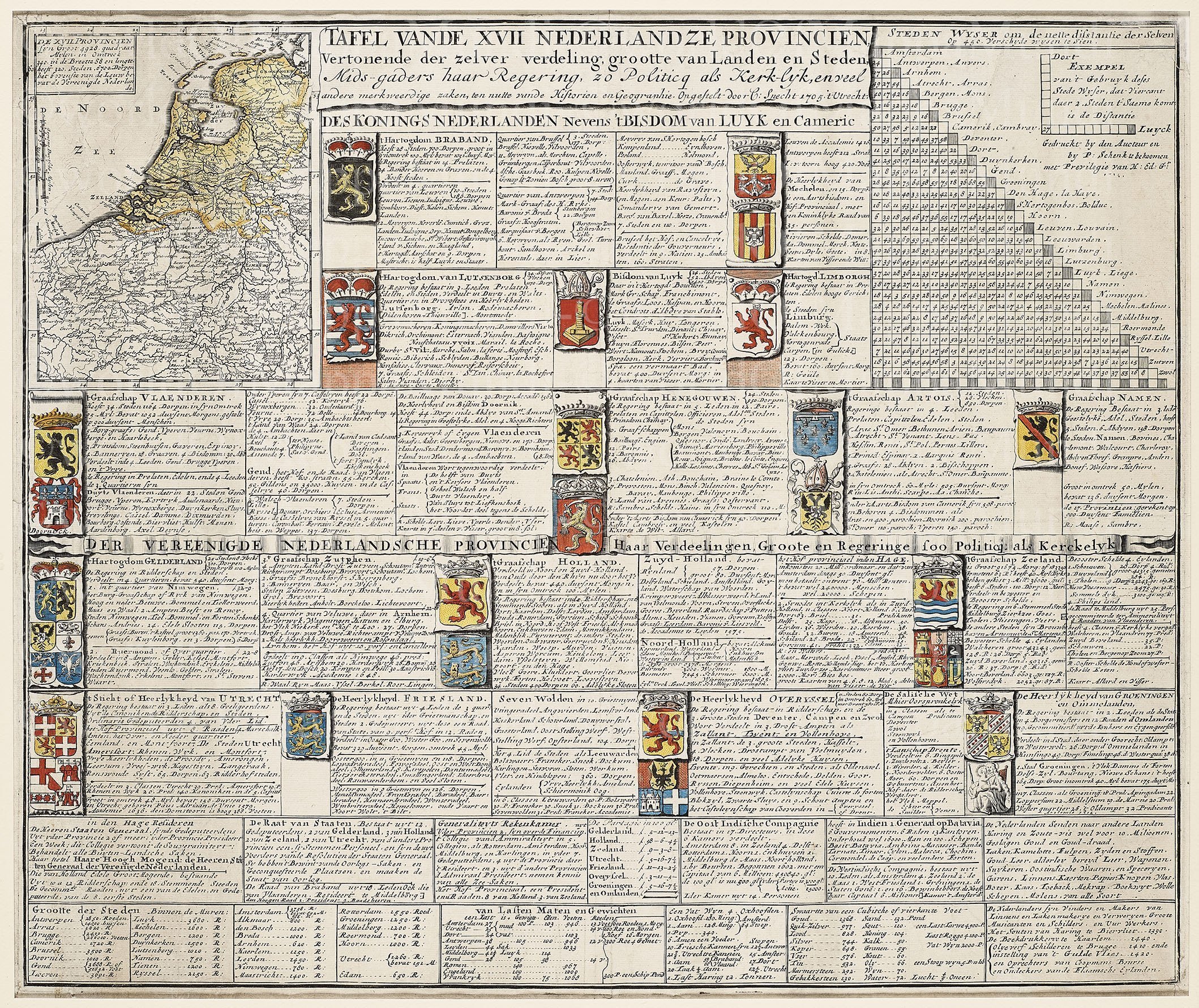
Descriptive Table of the XVII Provinces – Tafel Vande XVII Nederlandze Provincien Vertonende der zelver verdeling grootte van Landen en Steden, Mids-gaders haar Regering zo Politicq al kerk-lyk . . .
by
Caspar Specht
Rare table describing each of the XVII Provinces with coat of arms with small map of Leo Belgicus
Detail
Date of first edition: ca. 1705
Date of this map: ca. 1705
Dimensions (not including margins): 48 x 58 cm (Top left corner: map of Leo Belgicus 18 x 14 cm)
Condition: excellent. Sharp copper engraving printed on strong paper. Small tears, professionally restored. Old colouring.
Condition rating: A
Verso: blanc
Unless otherwise specifically stated on this map page, we charge the following expedition costs in euro (unfortunatelly, gone up with Covid, but still too low in reality!):
– Benelux: 40 euro
– Rest of Europe: 60 euro
– Rest of the World: 100 euro
This item is sold


Our commentary
This plate shows the “Tafel Vande XVII Nederlandze Provincien Vertonende der zelver verdeling grootte van Landen en Steden, Mids-gaders haar Regering zo Politicq als kerk-lyk, en veel andere merkweerdigezaken, ten nutte vande Historien en Geographie“. (i.e. a general informative table of the XVII Dutch Provinces).
It was printed by Caspar Specht around 1705. Surprisingly, the table still shows the Low Countries as one entity; but already separated in the middle. At the top: the “old” royal principalities; at the bottom the new republican provinces. Specht gives a comprehensive description of each principality/province with administrative subdivisions, their key cities and the number of inhabitants. The administrative organization is also described in detail.
This table also shows a total of 26 coats of arms. The crowns above the arms illustrate the hierarchical importance of the principality. The XVII provinces only held three duchies: Brabant (“of course” at top left) and Luxembourg (just below Brabant) and Gelre (Gelderland; more left). The duchy of “Limbourg” is currently situated much more in Germany. The county arms of, inter alia, Flanders towards middle-top left), Holland and Zeeland bear different crowns.
Further, one notices (in the top left corner) a “steden wyser”, which we identify as a modern distance table between cities. In the bottom Specht gives an overview of local weights and measures.
Such historical/geographic tables are very rare. More common was the publication of purely historical charts of nobility pedigrees per principality.