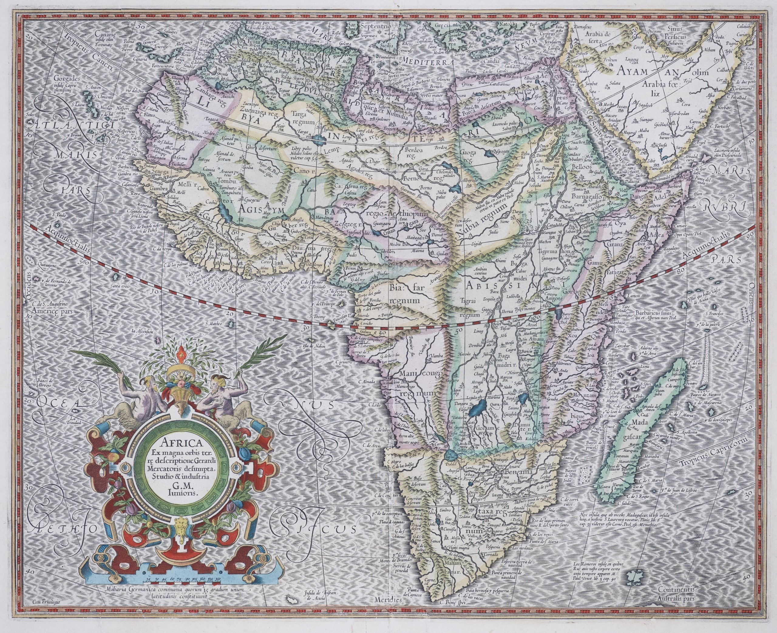
Africa – Africa Ex magna orbis terrae descriptione
Detail
Date of first edition: 1595 (Gerard Mercator’s grandson, also called Gerard Mercator)
Date of this map: 1628 (Henricus Hondius)
Dimensions (not including margins): 38 x 47 cm
Condition: Excellent. Centre old as published. Small tear in the lower margin just affecting the image, professionally restored.
Condition rating: A+
Verso: text in French
Map reference: Van der Krogt 8600:1A
From: Gerardi Mercatoris Atlas sive cosmographicae meditationes de fabrica mundi et fabricati figura. 1, 1:114
In stock
The most influential map of Africa
Gerard Mercator’s (i.e. the grandson of the Great one) finely engraved map of Africa depicts the continent as it was known in the late 16th century. This map is based on (the Great) Gerard Mercator’s twenty-one sheet wall map of the World, first published in 1569. This atlas version was indeed engraved by the Gerard Mercator’s grandson also called Gerard, in 1595, the year after the death of his grandfather (the great) Gerard Mercator. This map has a high degree of accuracy especially along the coastline that was unsurpassed by any other 16th century cartographer. Much of the interior of Africa defers to the traditions of Ptolemy; the Nile river is shown with two lakes and the Mountains of the Moon across southern Africa. Mercator does show European advance into the interior. For example, Mercator shows Portuguese exploration up the Cuama (Zambezi) River into the interior of south central Africa in the region of Monomotapa or Benamataxa, as he named it on his map. Ca. Portogal (the Portuguese Fort) is placed on the map within the junction of the Spirito and Cuama rivers.
Mercator tried to adhere to a more scientific approach and did not include the numerous beasts of other cartographers. The only figure within Africa is the seated legendary priest-king Prester John in Ethiopia. The cartouche is quite decorative with fruit and two satyrs. The fine script is superb and the sea has Mercator’s signature moiré pattern.
This map was probably made by Gerard Mercator, son of Arnold Mercator, who himself was a son of the famous Gerard Mercator. It was republished by Henricus Hondius in 1623.
