Fujian, Fu Chien or Fokien
Detail
Date of first edition: 1655
Date of this map: 1655
Dimensions (without margins): 40.4 x 48.5 cm
Dimensions (with margins): 46,7 x 55,7 cm
Condition: In excellent condition with full wide margins, on strong laid paper with superb watermark: Chinaman carrying a globe, centre fold as published, later cartouche and border colouring. Later colouring.
Condition rating: A+
Verso: blank (atlas in Latin)
Map reference: Van der Krogt 8431:2
From: Novus Atlas Sinensis a Martino Martinio Soc. Iesu Descriptus …’, Joan Blaeu, Amsterdam, 1655. Van der Krogt 2:501-2+4, page 12
In stock
Martini, M. and Blaeu, J.
Martino Martini (卫匡国) (1614-1661), was born in Trento, in the Bishopric of Trent. He entered the Society of Jesus in 1631, after finishing his schooling. He had a strong interest in astronomy and math, and he was able to study under Athanasius Kircher. Martini continued his theological studies in Portugal, on his way to Rome, and was ordained in 1639. He left Portugal for China in 1640, and arrived in Macau in 1642. He settled on the mainland in Hangzhou, Zhejiang Province, which he used as a base in his traveling around the country.
Martini had arrived in China at the very end of the Ming dynasty; in 1644, the last legitimate Ming Emperor, the Chongzhen Emperor, hanged himself. The Qing Dynasty then rose, and when Manchu forces came to the town where Martini was staying, he was asked to pledge his loyalty to the new dynasty. He agreed, and his head was shaved in the Manchu manner, and he adopted Manchu-style Chinese dress.
In 1651, Martini left China, taking an adventurous peregrination to Amsterdam by way of the Philippines and Bergen, Norway. He arrived in Amsterdam in 1653 and took his collection of manuscript surveys to Johannes Blaeu for publication. The collection of maps that Martini imparted to Bleau is worthy of close examination. He carried with him a copy of the Ming dynasty manuscript atlas by Zhu Siben (compiled 1311/12), with revisions from the printed atlas by Luo Hongxian — his “Guangyu tu” (enlarged terrestrial atlas, 1579).
Martini’s Novus Atlas Sinensis was published in 1655. He went back to China and settled in died at Hangzhou, where he died in 1661.
The Atlas Sinensis, apart from the technical excellence of its production, is important as being the first European atlas of China. It remained the standard geographical work on that country till the publication in 1737 of D’Anville’s Atlas de la Chine.
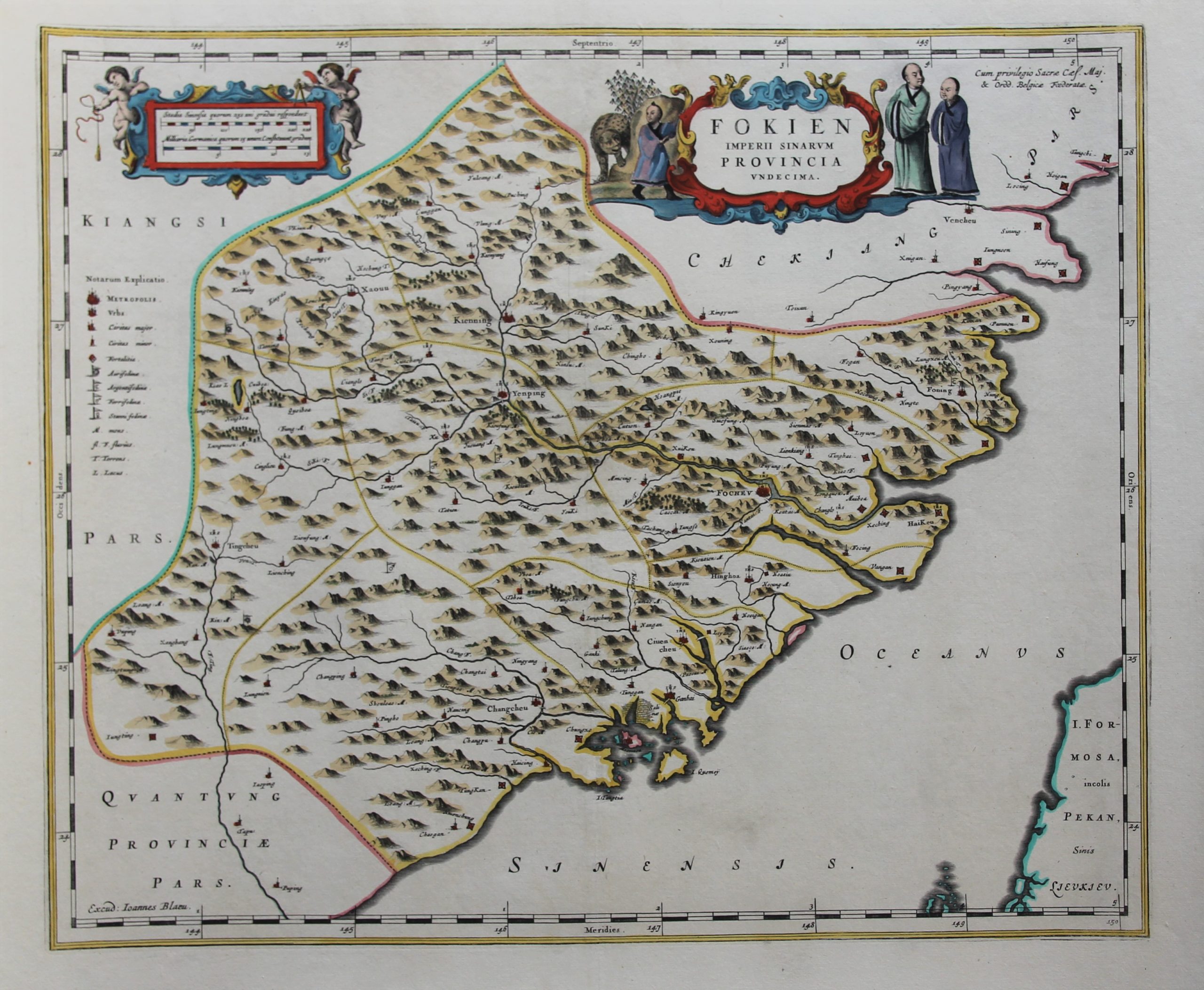
Fokien
The Fokien map is dominated by the city of Focheu (Fuzhou). In the right bottom corner one discerns the Northeastern corner of “Formosa” (now Taiwan, see below), empty land, and indeed no part of Ming China. Only in 1689, the Qing dynasty officially incorporated Taiwan into Fujian (current name) province, which explains why the Atlas does not contain a separate map of this island. And just across mainland China one clearly recognizes the tiny island of “Quemoy” which is now part of the Fujian Province of Taiwan; hence there are two provinces bearing the same name.
Concerning Formosa: In 1544, a Portuguese ship sighted the main island of Taiwan and dubbed it “Ilha Formosa” (from Latin formosus, meaning “beautiful”). The Portuguese made no attempt to colonize Taiwan as they were content with their trading posts in Kyushu, Japan. In 1624, the VOC established the first European-style government ever on the soil of Taiwan. Today, their visible legacy in Taiwan is limited to a castle in Anping District of Tainan City. The Dutch military presence concentrated at a fort called Castle Zeelandia. However, naval and troop forces of southern Fujian(most of this large influx of Chinese refugees were chased Ming supporters) defeated the Dutch in 1662, and they subsequently expelled the Dutch government and military from the island.
Title in a cartouche with Chinese figures at top centre. At top left a cartouche with putti containing mileage scales. Impressum at bottom left: ‘Excud: Ioannes Blaeu’.



Order of the atlas
Except for the frontispieces, the pictures of the maps follow the order in the atlas (see related item below):
1 Imperii Sinarum
2 Provincia prima: Pecheli sive Peking
3 Provincia secunda: Xansi (Shaanxi): see final picture as example of framed maps
4 Provincia tertia: Xensi (Shanxi)
5 Provincia quarta: Xantung (Shandong)
6 Provincia quinta: Honan (Henan)
7 Provincia sexta: Suchuen (Sizhuan)
8 Provincia septima: Huquang (Huguang)
9 Provincia octava: Kiangsi (Jinagxi)
10 Provincia nona: Nanking sive Kiangnan (Nan Zhili)
11 Provincia decima: Chekiang (Zhejiang)
12 Provincia undecima: Fokien (Fujian)
13 Provincia duodecima: Quantung (Guangdong)
14 Provincia decimatertia: Quangsi (Guangxi)
15 Provincia decimaquarta: Queicheu (Guizhou)
16 Provincia decimaquinta: Iunnan (Yunnan)
17 Iaponia Regnum (Japanese empire)
18 First frontispiece
19 Second frontispiece
In 2011 we published a study on the China maps by Martino in the cartographic journal of the BIMCC. Please find here a link to the first of three parts of this article: https://www.bimcc.org/uploads/newsletters/nl39.pdf